|
ROADS, AND THOSE IN TRING.
HIGHWAYS AND
BYWAYS.
|
“During the engagement of
Mr. J. E. Maynard as Surveyor of the roads in this county, he
has rendered great relief to different parishes employing the
superfluous poor collecting and preparing materials, and
introducing an advantageous plan for improving the highways.
In the Parish of Tring, Mr. Maynard in the space of nine months,
expended upwards of three hundred pounds assisting the poor who
otherwise must have been supported by parish relief.”
From the Tring Vestry Minutes
for 1822.
“It was ascertained by
Mr. Rogers one of the Guardians of the Poor that two of the men employed
on the road in Akeman Street,
‘Oakley
and Nash’,
were neglecting their work and sitting by the road side asleep.
He therefore took up their tools and discharged them. They both
said they
‘did
not care being turned off their work.’”
Tring Vestry Minutes, 22nd
April 1828. |
Ancient Roads.
The Tring Gap ― a lowering in the Chiltern Hills in which the town is
sited ― has provided the traveller and his animals with a thoroughfare
over the ridge since time immemorial. Two ancient highways, the
(Upper) Icknield Way and Akeman Street, crossed each other
in or near the modern town, although their point of intersection is
unclear.
The earliest written reference to the Icknield Way [1]
is contained in Anglo-Saxon charters of AD 903, [2]
but its true age remains something of a mystery. Thought to have
been one of a few long-distance trackways ― in fact a series of tracks ―
that existed before the Roman occupation, it followed the grass chalk
downland of the Chilterns, some historians claiming that it linked
The Wash in East Anglia with Wiltshire. However, in addition
to a lack of material evidence of its age, its route would have cut
across the local territories defined by regularly spaced hill forts and
dykes running perpendicular to the Chiltern escarpment. Before the
arrival of any strong central authority, movements along it in ancient
times would surely have involved travellers in numerous awkward local
negotiations, making its use as a long-distance trade route appear
doubtful.
Between Lewknor and Ivinghoe the track diverges into two parallel
courses, known as the ‘Lower’ and the ‘Upper’ Icknield Way.
Here a further uncertainty enters the debate:
|
“The Upper Icknield Way has all the characteristics of a
trackway, following the steep escarpment of the Chiltern range,
but the Lower Way is here peculiar in following a series of true
alignments on the flat land in a position unlikely for a
trackway and quite typical of a Roman road . . . . There can be
little doubt that this part of the Icknield Way is a true Roman
road.”
Roman Roads in Britain,
I. D. Margary (1955). |
Modern scholarship casts doubt on a ‘Roman’ Icknield Way due to
the scantiness of archaeological finds and proof of Roman road
construction. Perhaps for this reason ― and unlike nearby
Akeman Street ― its course is not marked on Ordnance Survey maps
(including the Ordnance Survey’s map ‘Roman Britain’).
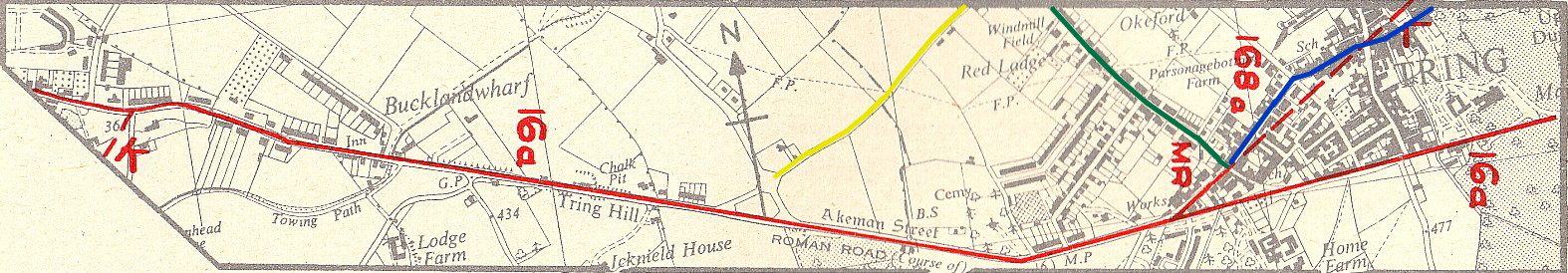
Nevertheless, archaeologists working during the 1950s mapped what they
believed to be the course of the ‘Roman’ Icknield Way. That
part of their map reproduced below shows the section of the Way (in red)
near Marshcroft Lane (in yellow) in Tring; to the left of the map, the
Way crosses Grove Road (in green), passes through the modern Chiltern
housing estate (yet to be built in the 1950s) and along Mortimer Hill
before entering the town centre to the north of the Robin Hood
public house. |

|
Thus, the age and line of this ancient road in this
locality remains a matter of conjecture, while its Romanization remains
a mere possibility (but more under Akeman Street below).
What is known is that by the Medieval period the Icknield Way
is referred to as one of the ‘Four Highways’ of the Kingdom, although
even here there is possible confusion between Icknield Way and
the Roman Ryknild Street. [3]
Much more is known about Akeman Street, [4]
sections of which are located and marked ‘Akeman Street, ROMAN ROAD’ on
Ordnance Survey maps of the Tring locality ― the road’s name,
incidentally, is not of Roman origin, but dates from the early Middle
Ages. Originally a late-Iron Age track, the Romans adopted
sections of it to form a road from Verulanium (St. Albans) to their
garrison towns of Alchester near Bicester and onwards to Cirencester.
Evidence for its construction and age is based on archaeological
excavations, such as that recently conducted in the parish of
Quarrendon, Bucks.:
|
“Akeman Street was sectioned at Billingsfield, Quarrendon,
revealing a gravel surface up to 6.6m wide, with flanking
ditches. The gravel surface had been constructed on a
raised bank of three make-up deposits, with a buried soil
possibly surviving beneath. The road seems to have been
constructed at an early stage in the Roman occupation, as two
cremation urns of mid 1st-century date were inserted into pits
cutting the edge of the outer ditch. Pottery from the
fills of the flanking ditches was 1st to 4th century in date
(Cox 1997). Related quarry pits and traces of make up
layers of Akeman Street were also encountered at the Aston
Clinton bypass.”
Roman Buckinghamshire,
R J Zeepvat & D Radford (2007). |
In 2011, Archaeologists undertaking excavations in advance of building
development at nearby Berryfields, Aylesbury, also uncovered the road’s
metalled surface and two pairs of flanking drainage ditches, the
characteristic profile of a Roman road.
|
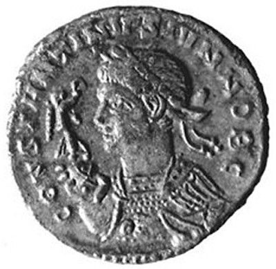 |
|
Roman coin
found at Cow Roast. |
Nearer at hand, behind the Cow Roast Inn
on the London Road, lie the remains of a Roman settlement that extended
to the hillside on the opposite side of the main road (A4251), beyond
today’s canal marina. Over the years this site has yielded many
valuable finds. As early as 1811, the
Gentleman’s Magazine reported the discovery of coins and a gold
ring, and other items such as military artefacts, pottery and jewellery
have been found over the years. Later excavations uncovered 14
well shafts, which together with other finds suggest that the site was
used for the production of iron. In addition to Roman remains,
there is evidence on the site of an earlier Iron Age settlement.
More recently another Roman site was discovered to the rear of the
now-demolished Old Grey Mare public house at Northchurch, but
pressures for new building prevented extensive excavations.
Work under the sponsorship of Dacorum Heritage Trust is still being
carried out to establish the exact line of the Roman road, while
evidence of Roman construction suggests a second road crossing north to
south in the Cow Roast area, presumably extending between Aldbury and
Wigginton.
That Akeman Street continued westwards to Tring was
established by
The Viatores, a group of researchers working during the
1950s. [5] They discovered that at the lodge entrance
to Pendley Manor, Akeman Street turns abruptly to west (shown on the
right of the map below) and then continues straight as far as Tring
cemetery. Its course through Tring Park is marked by part of an
agger, 45 feet wide by 1 foot high, [6] the excavation
of which revealed flint and gravel bound with lime mortar (more sections
of agger together with flint metalling were discovered in the vicinity
of New Ground). |

|
At the former Britannia Inn (now a private house at the
junction of Park Road and Western Road),
The Viatores conjectured that Akeman Street formed a
junction with the ‘Roman’ Icknield Way, the two then following a
common path to Aston Clinton. At Tring cemetery, the road turns to
the north-west (point AA above) before commencing the long alignment
across the Vale of Aylesbury (below). |
|
These maps were drawn in
the 1950s, since when Tring has become more built up and the new A41 has
appeared.
On the map above, the modern Icknield Way is shown above in
yellow, Miswell Lane in green, and Tring High Street in blue. The
certain course of Akeman Street appears as a solid red
line, while the presumed course of the ‘Roman’ Icknield Way
appears as a broken red line passing through Tring town centre.
Having shared a common path down Tring Hill,
The Viatores identified the junction of Stablebridge and
London roads (point K above) as that at which Akeman
Street and the ‘Roman’
Icknield Way diverged. During 2014, Archaeologists from the
University of Leicester excavated a site at this location prior to
housing development, and found evidence of both Iron Age and Roman
settlement. Their provisional dating suggests that the site in its
final form dates to the 1st or 2nd century AD, with activity in the area
continuing as late as the mid-3rd century AD.
The site was also found to be bisected in a south-west to north-east
direction by a wide (13m) trackway, the edges of which were defined by
long, straight ditches typical of a Roman road. Narrow ‘wheel
ruts’ were identified along parts of the carriageway, some of which had
been infilled with packed flint, possibly evidence of repairs, whilst
other broader spreads of flint could be the remains of metalling.
When viewed on maps of the wider area, the alignment of the trackway
matches the projected course of the Lower Icknield Way,
which might have its origins in the Iron Age or earlier. This
evidence appears to support the route of the ‘Roman’ Icknield Way
as conjectured by
The Viatores during the 1950s.
Market Street (now
the High Street).
“The street running through the centre of the Town, hitherto
known as Market Street, is changed, and will be called in future High
Street. It appears by an old record dated July 3rd 1711, that the
Street was then called High Street, so it is only reverting to its old
name.”
From the
Tring Vestry Minutes for 1833.
The original line of the approach to Tring, from both easterly and
westerly directions, as well as the actual route through the town, saw
many changes over the centuries. Consequently, it is confusing and
difficult to follow, especially as some traces of the old sections of
road have disappeared.
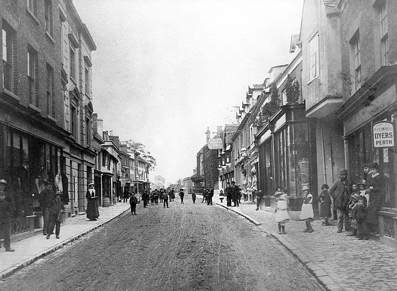
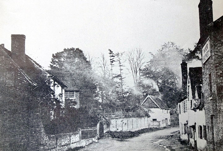
Tring High Street looking towards the old
Rose & Crown Hotel (on the right). Note
the condition of the
pre-tarmac road surface ― no wonder the road needed to be watered in
summer to suppress the dust.
A glance at a modern-day Ordnance Survey map shows that the most direct
route from Cow Roast to Tring follows the line of the age-old livestock
droving road to and from London, along the present A4251, until London
Lodge (the former Rothschild gatehouse) is reached. At this point
the old road continued straight through Tring Park, passing immediately
to the south the Mansion to emerge in Park Street. It then
continued along Park Road to form a junction with the present Aylesbury
Road at the old Britannia public house ― in Victorian times this
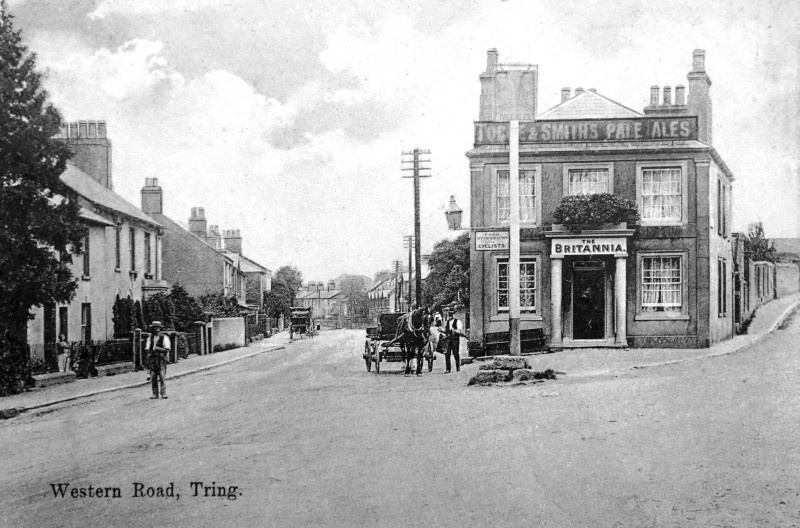
junction was known as ‘Bottle Cross’. [8]

The ‘Bottle Cross’
junction. The Britannia Inn is left of centre, the pub on the
right is
the
Bricklayers Arms
(note the horse trough).
The entrance to Duckmore Lane is on the extreme right.
The road then followed its present course past Tring Cemetery and
straight on towards Aylesbury and Fleet Marston (once a Roman road
junction).
The year 1711 saw a change to this age-old route, one that brought
increased prosperity to the town up until the end of World War II, when
the tremendous growth of road transport rendered the narrowness of the
High Street inconvenient and unsafe for large volumes of traffic.
In 1702, the Tring Park estate was acquired by Sir William Gore,
one-time Lord Mayor of London and wealthy banker. On his death,
the estate was inherited by his eldest son, William junior, who
petitioned that the main road be moved from the south to the north side
of his mansion because, it is believed, he disliked traffic passing his
dining room windows. Given the influence of the gentry in those
times it was probably a mere formality that his application for the
change was approved:
|
“At the house of William Axtell, Rose & Crown, Tring, an
inquisition was held relating to the enclosure by William Gore,
esquire of Tring, of part of the highway from Berkhamsted to
Aylesbury known as Pestle Ditch Way, which lies on the
south part of his garden from Dunsley Lane to a place called
Maidenhead. [9]
In substitution he will provide a road from Dunsley Lane across
Tring Market Street and New Lane to a place in his land called
Gore Gap.” [10]
Tring Vestry Minutes
11th January 1710. |
The inquisition was conducted before the Sheriff for Hertford, with
seven esquires, three gentlemen, and eight commoners forming the jury.
The verdict was, unsurprisingly, that there would be no damage to the
Queen or to others by the diversion of the highway for a distance of 92
perches (506 yards) [11].
This new route of the main highway as it reached Tring from the
Berkhamsted direction, still did not follow a line that would be
recognisable today. At London Lodge, it made its way to the south
of Lower Dunsley ― which was located near the site of today’s Dunsley
Place
(‘Donlee’ on the map below), but then a hamlet in its own right ― where
it wound its way between the houses, canvas factory and brewery to
emerge opposite the Robin Hood public house. From there on the
route corresponded with the present High Street until the ‘Gore Gap’ was
reached (in the map below, located at the road intersection above the
‘G’ of Tring), where the road turned south then immediately west along
Park Road, eventually to join the Aylesbury Road at the Bottle Cross
junction (in the map below, to the left of the ‘T’ of Tring).
|

Dury and Andrews’
map of Tring, c.1766. This map is a schematic illustration rather than one
drawn to scale.
Key: London Road ― red; Miswell Lane ― green; Frogmore Street/Akeman
Street ― blue; Brook Street ― purple; Park Road/Street ― yellow.
The hamlet of ‘Donlee’ (map centre) ― approx. today’s Dunsley Place ― was
demolished by Lord Rothschild in the 1870s.

Much the same area mapped by Andrew Bryant
c.1822. Western Road is shown, but no direct route from the town to the site of
its future railway station.
The feint double dotted lines around the
hamlet of Dunsley suggests the bypass section of the turnpike is under
construction, which ties in with what is known at this time.
Tring town centre today. Many new roads and houses
were built in the post WWII period.
|
At some time during the early 1820’s, a new section of road was created
between London Lodge and Dunsley, the work being undertaken for the
Sparrows Herne Turnpike Trust by James Bull of Tring. [12]
This necessitated some road widening, the demolition of dwellings and
payment of compensation. William Kay, the Lord of the Manor, was
awarded £248.15s.0d. compared with the £4.17s.0d. to the four cottagers
who were obliged to quit their homes. The main road now bypassed
Dunsley.

Above: a very early view (c. 1870s) of Tring
from the top of Station Road. The Manor Brewery at Dunsley
is on the left, its chimney shown ―
presumably it tapped one of Tring’s subterranean streams for its water.
Below: the only known view of the hamlet of
Dunsley. Manor Brewery is on the right.
Near the entrance to today’s Dunsley Place there survives a Grade
II listed monument of 1826, a white cast-iron milepost showing the
distance to London and nearby places along the road. The Sparrows
Herne Minute Book records that the Reverend Lacy (vicar of Tring
and one of the Trustees) designed the lettering and that an estimate was
requested from Mr J Dell, ironfounder of Dudswell, to form and cast the
plate.
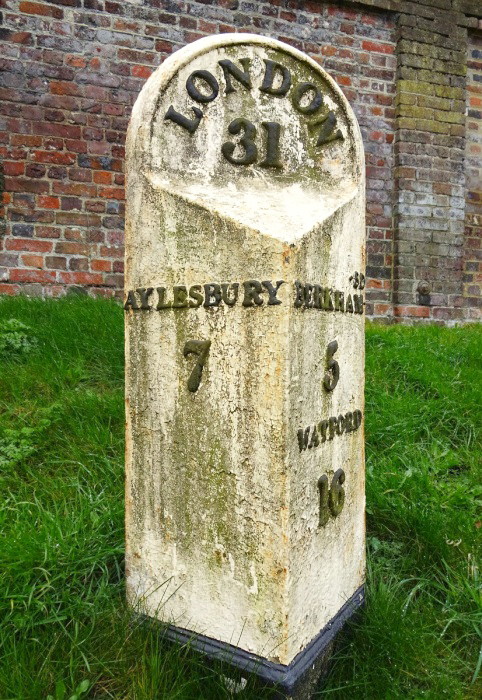
Sparrows Herne cast-iron
milepost c.1826.
Two original Sparrows Herne waymarkers still exist, at Bushey and at
Berkhamsted, and a replica can be seen in Tring mounted against the wall
of the Memorial Gardens, almost opposite the Robin Hood, where the
original was sited until 1991 when it was inadvertently lost during some
drainage work.

Sparrows Herne turnpike
waymarker (on the right) at Tring.
From the following entries in Tring Vestry Minutes and the
Bucks Herald it seems that the old road through Dunsley hamlet was
not closed until 1883:
|
1883. The old road at a point on the south side of the High
Street, adjoining the Manor Brewery, and the Canvas Factory, is
to be closed. This refers to Lower Dunsley.
1883, 25th August ― Notice has been issued notifying the
intended closing in the usual way of the now useless road at the
southern end of Tring . . . . |
Subsequently, Lord Rothschild decided to incorporate the whole area into
his private gardens, although it was some years before the Lower Dunsley
buildings were demolished:
|
DEMOLITION OF OLD BUILDINGS. ― The
Manor Brewery and houses at the bottom of High-street, on
the Station-road entrance to the town, which have been
unoccupied for some time past, are now pulled down. It is
almost needless to say that they will not be rebuilt, as
they are on the confines of Tring Park.
Bucks Herald, 11th January
1896. |
Western Road.
In 1822, the turnpike trust drove a new section of road straight through
the grassland between the Gore Gap and Bottle Cross:
|
“The trustees of the Sparrows Herne Turnpike are making most
excellent improvement in the road at the Aylesbury entrance of
the town of Tring, by cutting an entirely new line through the
inclosures, to avoid the present dangerous turn of hill.”
Morning Post 7th
February 1822. |
At some date between 1860 and 1870 this stretch of road came to be known
as ‘Western Road’, a name originally referring to the section between
Akeman Street and Langdon Street, later to become the (Upper) High
Street. Before the construction of the ‘new’ Western Road, the
age-old approach into the town centre from the westerly direction was as
equally convoluted as that from the east. In addition to the Park
Road route, at the Bottle Cross junction a road then existed that veered
north, then east, winding up Abstacle Hill, crossing Miswell Lane to
join a track (now Christchurch Road) where it turned south to connect
with the main road at the Gore Gap.
Following the 1822 alteration, the route of the highway through the town
was complete and remains that with which we are familiar today.
However, the steepness and narrowness of the High Street continued to be
far from ideal for use by Royal Mail stagecoaches and other horse-drawn
traffic.
Beggar Bush Hill (now
Tring Hill)
[13]
First suggested in 1810 and again in 1816, it was not until around 1824
that alterations to the western approach to the town in the Tring Hill
area were undertaken by the Sparrows Herne Turnpike Trust. In
order to reduce the gradient a considerable amount of excavation took
place to reveal the chalk cutting seen today in the vicinity of the
Crow’s Nest motel.
The following advertisement appeared on 22nd November 1823 in the
Windsor & Eton Express (later the Bucks Gazette):
|
SPARROW’S HERNE TURNPIKE
To Road Contractors, etc.
Such Persons as are willing to CONTRACT for the necessary works
in CUTTING THROUGH and LOWERING BEGGAR BUSH HILL, on the
Sparrow’s Herne Turnpike Road, between Tring and Aston Clinton,
are desired to send Tenders in Writing to the Office of Messrs.
Grover and Smith, Solicitors, at Hemel Hempstead, Herts, on or
before the 6th Day of December next, to be submitted to the
Trustees at a MEETING on the 8th of DECEMBER. A Plan and
Specifications of the works may be seen at the Rose & Crown,
Tring, the Bell, Aston Clinton, at the Office of Messrs. Grover
and Smith, and at Mr Creed’s, Surveyor, Hemel Hempstead. |
Various tenders were laid before the Trustees on 8th December 1823, who
decided to award the construction contract to James Bull of Tring and
Thomas Morris of Aston Clinton, the former being the preferred choice of
the Trust’s Surveyor, the famous engineer James (later Sir James)
McAdam. Three days later, a Bond for the Performance of Covenants,
and an Agreement [14] were drawn up and signed by all
parties. |
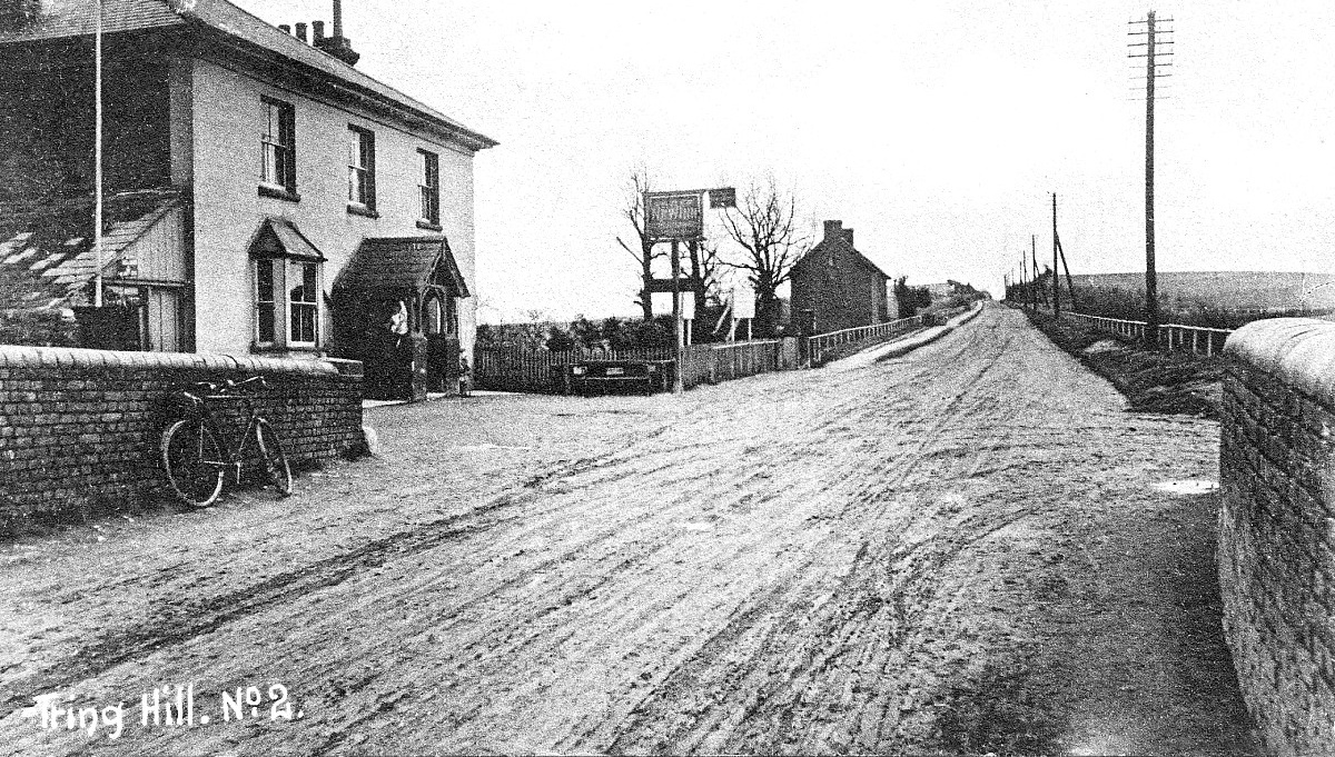
This view of Beggar Bush Hill ― now Tring Hill ―
clearly shows the cutting driven through the
ridge in 1824,
lowering it by 36 feet, and the even gradient that resulted.
Note the condition of the pre-tarmac road surface! The public
house on the left, the New Inn, is now business premises.
|
In addition to the excavation work and the provision of a temporary
roadway whilst the work was in progress, the contract included the
necessary embanking, fencing, quicking (i.e. hedging), rails and
culverts, and a payment by the contractors of £500 to be laid down as a
sign of ‘good intent’. The work was to be complete by 1st December
1824. Pauper labour was provided by the overseers of Tring
Workhouse [15] and the total cost amounted to £2,416
1s. 3d.
However good the surface was then considered, a letter [16]
to the Trustees from farmer John Edmonds of Buckland Wharf written in
May 1825 showed little appreciation, for he complained that the state of
the hill nearly caused him an accident with a load of hay on board ― “.
. . . it was a good road before the Hill was took down . . . .”
Some 40 years later the Bucks Herald was grousing:
|
1867, January. TRING. “We have many complaints made to us of
the state of the turnpike road between this town and Aylesbury.
The hill at Beggar’s Bush was almost impassable before the late
frost. Surely the Trustees will see to it?” |
|
 |
|
Uncle Tom’s Cabin
cafe with Mr. Pratt, its proprietor,
standing proudly
in the doorway. |
A curiosity that once stood on Tring Hill is remembered by some of the
Town’s older folk. Sometime before WWI, Mr and Mrs Dodd of Henry
Street set up a stall halfway up the northern side of Tring Hill, from
which they served light refreshments to passers-by. Around 1914,
Mr and Mrs Pratt obtained permission to place two disused railway
carriages on the same site, one being used as a café and the other as
living accommodation; a disused chalk pit on the opposite side of the
road served as a pull-in for lorries and cars. They named their
pride and joy ‘Uncle Tom’s Cabin’.
During WWII the café became a venue for dinners and wedding
receptions, and due to its comparatively isolated position was also the
target for a number of break-ins, reports of which appear in the local
newspapers of the time. The structure remained until sometime in
the 1960s, Bill Pratt dying in 1974. This poor reproduction
photograph shows him standing in the doorway.
Station Road.
Station Road is not one of the town’s old roads. Built in 1838, it
provided a direct link between the town and its distant station using
donated land and funds raised by private subscription. Prior to
its construction, the journey from Tring to Pendley and Aldbury followed
a tortuous route, which local historian Arthur MacDonald described in
his notes on the subject (c.1890):
|
“At the east end of
the town important alterations were necessitated by the
construction of the railway, and station in 1838. The
traveller by road from Tring to Aldbury before that date
proceeded up the London Road to Dunsley, turned back across the
3-cornered meadow, following the hedge next the present cricket
ground, to the point where The Laurels now stands, and which was
then the corner of Grove Shrubbery, the latter extending right
round to the fir tree near the recreation ground. Skirting
the shrubbery, as far as Grove Lane, our traveller would then
turn up Cow Lane for a little distance, and strike across what
is now Pendley Park, between the Rookery and a small spinney,
emerging some little distance short of Pendley canal bridge,
this latter part being the ‘Aldbury Road’ mentioned in the
Inclosure Award.” |
Following the railway’s arrival, it soon became apparent that the
popularity of this new form of transport necessitated better
communication between the town and its station:
|
“A meeting of the
Parishioners was held to consider the proposed diversion of the
highway from the Town to Pendley. The inhabitants gave
their consent to the proposed diversion. The consent of
the inhabitants was also given to the stopping of the footpath
leading to Pendley across Dunsley Farm to the swing gate and
also to the footpath across Pendley Park as far as the path is
in the Parish of Tring. The above consents were
conditional on the part of Thos. Butcher Jr. & John Brown on the
understanding that the ratepayers were to be called upon to pay
£300 towards the execution of the New Road and the payments were
to be distributed over 6 years.”
Tring
Vestry Minutes 17th October 1837.
“The inhabitants of Tring have held a meeting at which it was
agreed to form a new road from the town to the station.
Mr. Kay and Captain Harcourt having given the land for that
purpose, and the needed funds raised, buildings are already in
progress, and the inhabitants are making every exertion to
accommodate the public that every day throng this beautiful
neighbourhood, which, from the variety of hill and dale, wood
and water, combined with the extensive views it commands, is
likely to become a place of importance.”
The Bucks Gazette,
28th October 1837.
“The new highway from Tring to Pendley, to be known as the
Station Road, is completed, and in good condition.”
Tring
Vestry Minutes, September 1838. |
In his notes on the Town’s history, Arthur MacDonald leaves a brief
mention of Station Road’s builders:
|
“Bank Alley
[off Tring High Street] (now
occupied by Mr William Johnson, butcher) was formerly the
emporium of Mr Bull, saddler, a leading man in the place and
very wise in road making. He superintended the formation
of the
cutting embankment at Beggar Bush Hill on the
Aylesbury Road, also the making of the new Station Road in 1838,
when he and Mr William Brown were Highway Surveyors. He
held the post of Parish Constable at the same time, with great
effect upon unruly railway navvies.” |
While one might argue that Tring never became the place of importance
envisaged by the Bucks Gazette, Station Road is, nevertheless, an
important highway carrying a high volume of traffic during the commuting
periods to and from the Town and its increasingly built-up surrounding
area.
Other roads
leading from the main highway.
Sunken roads.
From the earliest times until well into the 20th century, the principal
pursuit in this locality was agriculture. Originally, the land
would have been covered with woods and open rough scrub that people used
to graze their cattle, sheep, pigs and geese; this came to be known as
common land, or simply as the ‘common’ and the right to its use was
guarded jealously by the local parishioners:
|
“At a Publick Vestry it was agreed that whereas the Scrubs &
Heath upon Tring Common have been unlawfully cut by persons not
inhabitants of this Parish to the great detriment of the Poor
and the Parish in general. Also several persons have made
a common practice to take up the sheep dung from the Common to
the great damage thereof. Now to prevent these practices
and that there may not be any further incroachments We do hereby
agree that John Geary shall be appointed a keeper of the Common
to prevent any person not inhabitants from cutting the scrub,
gathering the dung and also to impound the cattle of any person
which shall unlawfully depasture the Common.”
Tring Vestry Minutes, 4th May 1773.
At the Vestry held by adjournment to consider the best
method to proceed to prevent the Parishoners of Wigginton
from trespassing upon the
[Tring]
Common. It is ordered that Sanuel Herbert Attorney
shall as soon as possible search all the Ancient Records
belonging to this Parish and enquire of and find out such
ancient people as formerly belonged to this Parish and get
what light may be obtained in regard to the
[Tring]
Common and when he has obtained the same lay it before the
whole Vestry to consider what steps shall be taken.”
Tring Vestry Minutes, 2nd July 1773. |
Livestock were put out each day, often supervised by the very young or
infirm, and each night returned to the farm. The farm needed to
have direct and convenient access to the common, and tracks from farm to
common eventually became worn and sunken through constant use, sometimes
further sunken over the years by the action of torrents of rainwater
sweeping down them. Many of these tracks exist today as ‘sunken
roads’, also known as ‘holloways’, particularly in areas of soft chalky
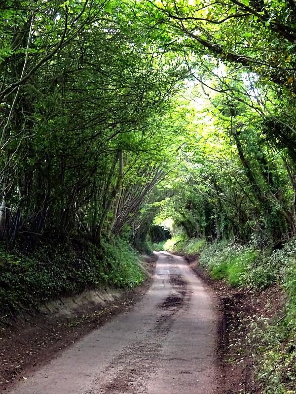
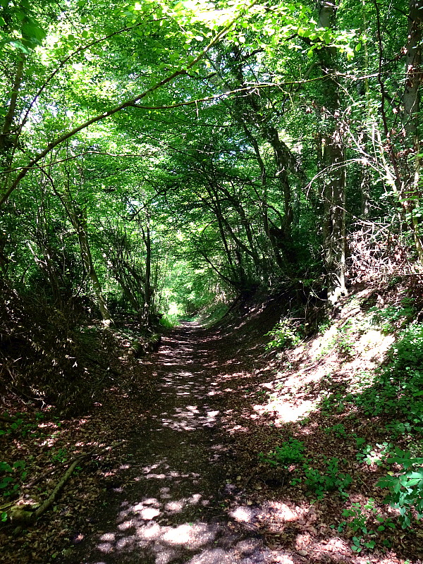
ground into which tracks are easily worn. They are characterised
by high embankments on each side, sometimes topped with hedges and trees
that can give the traveller the impression of passing through a tunnel.
There are a number of sunken roads in the Tring locality, although long
out of use for their original purpose. Some, such as that from
Icknield Way to Drayton Beauchamp and that from Tring to Hastoe, have
been given a metalled surface and made over to motor traffic.
Others, which no longer serve any socio-economic purposes, such as Leafy
Lane between West Leith and Hastoe, have become footpaths/bridle ways
for leisure use. Their history goes back to Saxon times, when
arable land in the vale of Aylesbury was considered too valuable to use
for grazing, so during the summer months the communities in the
localities of what today we know as Buckland, Drayton Beauchamp,
Wilstone and Marsworth drove their animals up into the hills in the
vicinities of today’s St Leonards, Cholesbury and Hawridge to graze on
the scrubland. Over time, as centralised administration became
established, elongated parishes came to be established in which
villages/hamlets located on the plain had a counterpart several miles
away in the hills ― perhaps the most obvious example on today’s map is
the village of Buckland in Aylesbury Vale, the grazing land for which,
Buckland Common, is located on the ridge of the Chilterns some 5 miles
to the south-east. A number of these elongated parishes remain as
historical curiosities, several miles long but often no more than a
half-mile wide, together with traces of their sunken roads ― some
metalled others footpaths ― that linked them with their former summer
grazing. |
|
 |
 |
|
Sunken roads (Holloways) near Tring. |
|
Bottom Road (metalled) near Dancersend. |
Footpath through Pavis Wood, Hastoe. |
|
Local roads.
Other traffic by foot or by horseback was mostly within the immediate
area, between farms and nearby hamlets, and to any local town, such as
Tring, where the church [17] and market would have
been the main destinations:
“The market is held on Fridays according to a
charter of King Charles II, who decreed that straw plait should be sold
in the mornings and corn after mid-day. A great deal of business used to
be transacted at the markets, but practically no straw work is sold now
except a little fancy plait, and the corn market has dwindled to three
or four purchasers. The chief corn trade of the town is now done by
auction at the fat stock market, which is held on Mondays. There was a
market-house at Tring in 1650, with a court loft over it, in which was
held the court baron and leet of the manor.”
Victoria County
History ― Hertfordshire (1908).
Direct cross-country routes would have been taken, which, over time and
through customary use became a ‘way’ (footpath, lane or road).
Other reasons for a way into a town developing were the need to
transport building materials (flint, bricks and tiles) by packhorse from
local pits and brickyards, of which there were a number in the Saint
Leonards/Cholesbury area. There was also a need to transport grain
for malting and brewing in an age when, due to unsafe water, much more
beer was drunk than today.
And so, over the centuries, a network of ‘ways’ developed into the town.
By the date of the first Tring Estate map (1719) and that of Dury
and Andrews (1766), the town’s principal roads were established ― these
we know today as Akeman Street, Frogmore Street, Miswell Lane, Mortimer
Hill and Grove Road/Cow Lane.
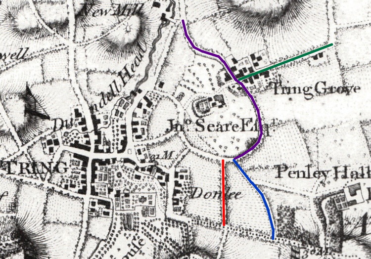
Tring Grove, then a hamlet ― Dury and
Andrews c.1766.
Key: Gove Road, purple; Marshcroft Lane, green; Cow Lane
Blue; unnamed lane (now a footpath), red.
It seems that a windmill (vide map, top, left of
centre) once stood in the vicinity of
today’s Lakeside, from which the area ― still called ‘New Mill’ ―
takes its name.
The maps above and below illustrate a few instances of the changing face
of Tring in the Grove Road area. The Dury and Andrews map above
(c. 1766) shows the hamlet of Tring Grove. At that time, much of
the land in that area belonged to John and Mary Sear, who inhabited
Grove House. According to a contemporary description, their estate
comprised a large manor house, large walled garden, pleasure
ground and shrubberies ― the site of which Dury and Andrews mark on
their map ― together with farm land. Mary Sear died in 1807, by
then a widow. Sometime afterwards the property was let, but did
not survive long. In 1811 the house was surveyed and found to be
in a very dilapidated condition, and it was recommended that it should
be demolished and the materials sold. When this happened is not
clear, but Bryant’s
map of 1822 shows what appears to be the walled garden without the
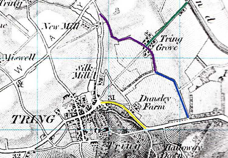
house, while on the Ordnance Survey map below (1822-34), all trace of
Grove House has disappeared.
Other noticeable differences between the two maps are that the
road across Little Dunsley Field, shown above in red, has disappeared ―
although a footpath still survives ― while the hamlet of Dunsley is
bypassed by new road construction (yellow on the map below) built
c.1822, which corresponds with today’s
alignment.
The Brook Street/Wingrave Road/Tringford Road area also experienced
change during the first half of the 19th century. This followed
construction of the windmill and canal wharf at Gamnel c.1810, the Silk
Mill in 1823, and the Gas Works in 1850, while later in the century a
boat-building business (later to become Bushell Brothers) also opened at
Gamnel. New housing was later built along these roads, together
with a school (Gamnel Road School) and public house (The
Queens Arms), to serve these working in the area, much of which
survives. |
|
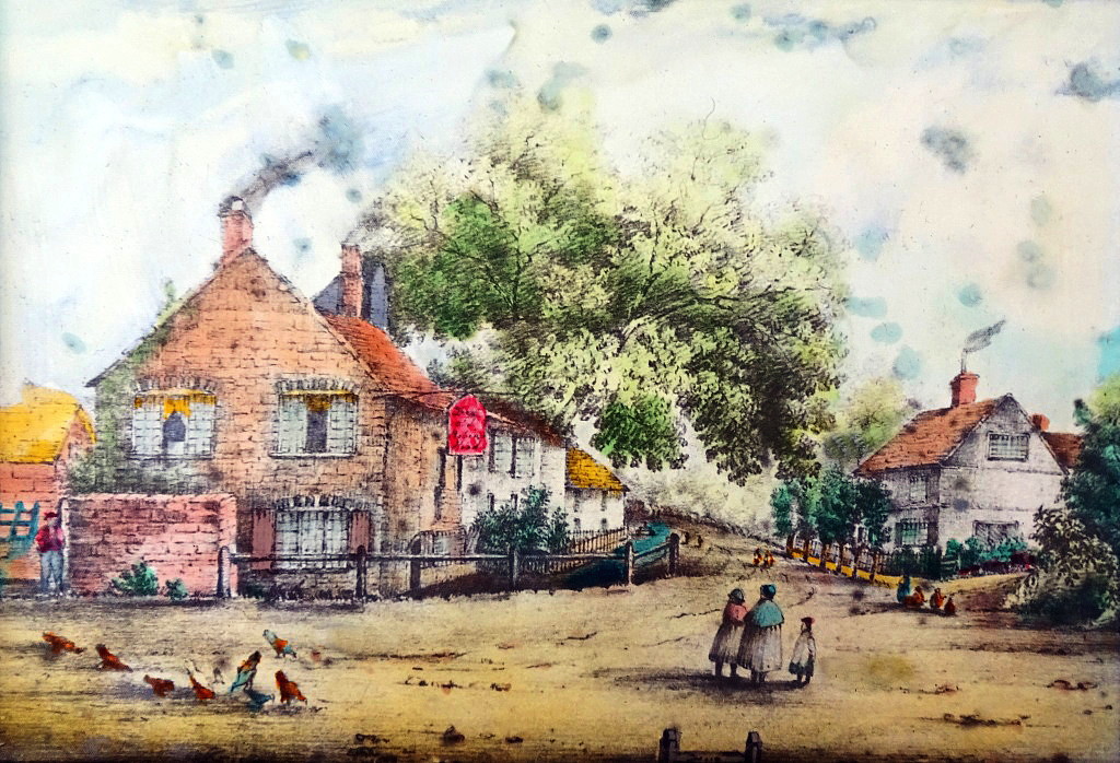
The Old Robin Hood, Brook End.
The vent of the pub’s
maltings (see also below) is just visible behind the second chimney.
The date of this watercolour is unknown. It shows the brook from
Tring Park, after which Brook Street takes its name, running beside the
Robin Hood Inn. The brook does not appear in old photographs, but
whether it was diverted or culverted is not known. The building on
the right is Wigginton Manor. It was here that Wigginton’s legal
affairs were dealt with, but the building was not a manor house.
Apparently wrongdoers from the village were brought down to Tring to be
placed in the stocks, which are just visible at the bottom of the
picture. |

|
An undated photograph of
Brook End.
Inclosure.
Inclosure (modern spelling ‘Enclosure’) came at the end of the 18th
century. It was the process of physically changing the landscape
to benefit the development of modern farming practices as technology
improved. Initiatives to enclose came either from landowners
hoping to maximise rental from their estates, or from tenant farmers
anxious to improve their farms. Originally, land enclosures took
place through informal agreement, but during the 17th century the
practice developed of obtaining authorisation by Act of Parliament.
Under the Inclosure Acts, open fields and common land were enclosed with
fences, hedges, ditches or embankments, thereby creating legal property
rights over areas that had previously been considered common land.
Inclosure was carried out on a parish-by-parish basis, in the process
changing the layout and size of fields, and thus the routes of roads and
other rights of way. Prior to inclosure, villages were surrounded
by large, hedgeless ‘open fields’ that were farmed in strips.
The plan below, from 1793, is a part of the set of plans for the Grand
Junction Canal then being built. It relates to the Wendover Arm,
and is interesting for showing the strips of common field that then
existed at Little Tring before inclosure took place. |

|
Each plan is accompanied by a schedule that gives, for each strip, its
tenant, its area (in acres, roods and poles) and how much the
canal company paid for it (although at the
time this plan was drawn up the land had not yet been bought). For
instance, in the plan above, strips 25 & 27 belonged to Drummond Smith
Esq.; strip 26 to James Harding; strips 1, 2 & 3 to Mrs Mary Sear (of
the Grove); strip 4 to William Butcher; and so on.
Inclosure first took place in Tring in 1799 under an Act of Parliament
of 1797 (37 Geo. 3, C. 35) entitled “An Act for
dividing, allotting and inclosing the open and common fields, common
meadows and common pastures and waste land and ground within the parish
of Tring in the County of Hertford”. A survey was made,
and the enclosure was drawn up on plans. The Act granted the
enclosure commissioner the necessary powers to create new public rights
of way, and new roads were included of a specified width:
“. . . . the said Commissioners, or any Two of
them, shall, and they are hereby authorized and required, in the first
place, to set out and appoint such Public Roads and Ways in, over, and
upon the Lands and Grounds by this Act directed to be divided, allotted,
and inclosed, as they shall think necessary and proper; and that all
such Public Roads and Ways (except Bridle and Footways) shall be and
remain Forty Feet wide at least, and shall be fenced on both Sides
thereof by such Person and Persons, and in such Manner, and within such
Time, as the said Commissioners, or any Two of them, shall order or
direct . . . .”
Not only was the medieval field strip system abolished in favour of
enclosed fields, but new roads and footpaths designed to improve
communications were also established for what today would be called
‘minor roads’ and also for the more important ‘carriage roads’.
All these roads had to be fenced and at least 40 ft. wide, one clause
from the Act stating that:
“. . . . after the said Roads and Ways shall have been set out as
aforesaid, the said Commissioners . . . . shall . . . . appoint some
proper Person or Persons to be Surveyor of the said Carriage Roads; and
such Surveyor shall cause the same to be properly formed and put into
good and sufficient repair . . . . And that none of the Inhabitants of
the Parish of Tring shall be charged or chargeable …. towards the
forming or repairing of the said Roads until the same shall be made fit
for the passage of Travellers and Carriages, and shall be certified so
to be by the said Surveyor”.
In Tring, these new ‘Roads and Ways’ leading from the main highway
appear, more or less, to have followed the existing routes, but some of
the road names have since been changed while others are now incorrect.
For more details see Appendix I.
During the mid-Victorian period, Tring experienced a building boom, and
the part of the town ― now a Conservation Area known as the ‘Tring
Triangle’ ― became built up. The Local Board, comprising
elected members, decided on the line of new streets, and much land
changed hands. James Honour, a prominent local builder, was
requested to submit a street layout plan for the western side of Tring.
As with any committee, matters did not progress smoothly, and in 1865
one in a sequence of rows is reported, when “the
Clerk resigned on account of the publication of a printed circular
signed by the Chairman in which his ‘professional honour’ was called in
question. The Chairman again left the chair of the meeting, and the
question of Mr Honour’s roads was abandoned.”
Eventually, all was settled, the result being the network of small side
streets, some bearing royal names, on the south side of Tring. For
more details relating to the streets in the heart of the Tring Triangle
see
Appendix II.
Costs and Disputes.
Disputes over matters relating to roads were nothing new. Tring
Vestry Minutes record that prior to Victorian times, laws were passed in
the reigns of James I and Charles I applying to the supply and upkeep of
royal carriages for use on public highways. These demands were
considered outrageous by many ordinary citizens, including those in
Tring:
|
1625, January. At the Hertford Sessions, that whereas
for the earlier discharge of the King’s carriages the County in
general agreement in regard of the great disability of these
parts adjoining Theobalds and Royston, that the burden of such
carriages should be borne by contribution of the whole county,
but the inhabitants of the towns of Aldbury, Tring, Berkhamsted,
and the hamlets of Long Marston and Wilstone, and divers others,
obstinately refuse to pay the same and also refuse to appear at
the Sessions, or before any Justices. The Court now
desires certain Justices to attend the Board of Greencloth
[18]
to crave their assistance for the reformation of the said
abuses, by calling the said comtemptious [sic]
persons before them, and enforcing them to pay all such moneys
as are due from them.
1669, April 1st. At Hertford Sessions, presentations
by Sebastian Grace, John Dagnall, John Harding, Thomas Seabrooke
and John Foster the elder, all of Tring, that they refused to
assist in repairing the highway at Long Marston. |
Financial problems were sometimes settled amicably and sensibly, some
examples from the Tring Vestry Minutes include:
|
1767, 28th January. At a Publick Vestry it is agreed
between John Seare of Tring Grove, viz. that they will so as
they
[presumably members of the Vestry]
may, or can deliver at their own expense upon parts of the
commonly called New Road, 20 loads of stones annually towards
the repairing of the road and will excuse the duty John Seare
upon the other bye roads of Tring Parish so as he perform his
duty on the New Road without calling upon the Surveyors to allow
or provide anything further towards the repairs thereof. Signed
by John Seare and other names.
1822. During the engagement of Mr J H Maynard as
Surveyor of the roads in this county, he has rendered great
relief to different parishes; employing the superfluous poor
collecting and preparing materials, and introducing any
advantageous plan for improving the highways. In the parish of
Tring, Mr Maynard in the space of nine months, expended upwards
of £300 assisting the poor who otherwise must have been
supported by parish relief.
1826. At the Hertford Sessions, the inhabitants of
Tring were indicted for not repairing 2,500 yds. of road to
Chesham, starting at an oak tree in Little Meadow, the property
of William Kay Esq., at Hastoe Cross, and ending at a gate on
Cholesbury Common which marks the boundary between the counties
of Hertford and Buckingham. The Court discharged the case, upon
a certificate being produced that the road had been repaired.
1826. It was ascertained by Mr Rogers, one of the
Guardians of the Poor, that two of the men employed upon the
road in Akeman Street (Oakley and Nash) were neglecting their
work, and sitting by the roadside asleep. He therefore took up
their tools and discharged them. They both said they “did
not care about being turned off their work”.
1838. A letter was sent to the Hertford Sessions by
the Sparrows Hearne Turnpike Trust stating that in consequence
of the great reduction in the income of this road occasioned by
the L & B Railroad, the trustees find that they are under the
necessity of throwing upon the county the repair of all county
bridges on this road, and of 300 sq.ft. of the road at each end
of such bridges. They request that the County Surveyor be
instructed to attend to these repairs. |
Local costs were scrutinised in detail and with care, and sometimes
matters had to be thoroughly investigated. It is not recorded how
these examples below from Tring Vestry Minutes arose:
|
1856, 2nd May. Tring. J Grover’s accounts as Surveyor
of the Highways were brought before the Vestry who refused to
pass them. The Reverend James Williams of Tring Park said
that he strongly objected, and they must be examined by the
magistrates.
1856, 28th May. Tring. J Grover’s accounts were
brought before the magistrates, and after some discussion they
were ultimately passed. With the exception of £4 Grover
had incurred for Law expenses, which were not allowed, and
Grover must pay them himself. General satisfaction is felt
in the town at the result and gratitude to the Reverend Williams
for his stand in this matter. |
Drains and Lighting.
Ten years later, concerns were being expressed
about the dire state of Tring’s drains, and deputations from the Local
Board travelled to large towns such as Northampton to seek advice on the
matter; in 1866 a very large sum was borrowed and improvements gradually
started to be implemented, as well as the on-going work entailed in
providing a mains water supply.
In 1870, the Grand Junction Canal Company came into legal conflict with
the Tring Local Board of Health over contamination of Tringford
Reservoir and the spread of disease:
“Part of the
drainage of this town
[Tring]
is carried away by a sewer which empties itself into the
canal-reservoir to the north. Before this sewer was made the
reservoir received only spring-water, a matter of some
importance, as some neighbouring villages drew their water from
the stream that flows from the reservoir. After the
turning in of the sewer, in summer, when the water in the
reservoir was low, it stank abominably; and worse, diphtheria,
typhoid fever, and other such diseases, were frequent in the
villages.”
The Water Supply of Buckinghamshire and of
Hertfordshire, W. Whitaker (1921).
The canal company sued for damages. They complained of the
pollution and of the additional expense incurred in pumping water up
from Tringford reservoir that would otherwise have flowed directly into
the Wendover Arm along Tring Brook and were granted an injunction
against the Tring Board of Health, the Lord Chancellor ruling that “the
right of enjoyment of surface water in a flowing stream must not be
interfered with” ― public health issues did not appear to enter into
the argument! Standards of public health have of course improved
out of all measure since 1870, and today the canal summit obtains a
useful supply of cleaned water from Tring sewage works.
During the ten years preceding WWI the Council was again much
preoccupied by the essential question of laying a more modern sewerage
system in certain parts of the town. This work got underway in a
piecemeal fashion and major road works were again necessary as pipes had
to be laid beneath road surfaces.

Laying the new sewer in Langdon Street
aroused sufficient local interest for this
postcard to be made to record the
event.
――――♦――――
APPENDIX I.
Roads created from Tring by the Inclosure Act of
1799.
Wingrave Road was a continuation of Frogmore Street. It extended
from Bunstrux Hill through Little Tring and Tringford (i.e. the area
adjacent to Tringford and Startop’s End reservoirs) to Long Marston. The
present Wingrave Road in New Mill appears to be incorrectly named.
Winslow Road led from London Road at Pendley Beeches (i.e. the
wooded area to the east of the Cow lane/A4251 junction) passing along
Cow Lane and Grove Road to Wingrave Road at Tringford.
Windsor Way was the road forming the boundary between Tring and
Wigginton parishes set out under the Inclosure was half the specified
width at 20 ft. and this was paid for by Tring, the remaining half being
left for Wigginton to undertake. In the event, the villagers found the
20 ft. sufficiently convenient without further outlay.
Aldbury Road led out of the Winslow Road about halfway up Cow
Lane, it extended over what is now Pendley Park until it reached Aldbury
Parish boundary. This road was rendered redundant in 1838 following the
opening of Station Road.
――――♦――――
APPENDIX II.
Streets in the ‘Tring Triangle’.
Streets in the heart of the Tring Triangle:
[this information is obtained from various individuals – all now
deceased - and may contain errors!].
Langdon Street (known from 1711 as the ‘Gore Gap’) took its name
from George Langdon of Old Street, City Road, a linen manufacturer, who
died in 1827. He owned two pieces of land amounting to four acres
in Gravelly Furlong Road, an area on the east side of Langdon Street.
This straight road connected Park Road with the old road, which ran from
Abstacle Hill to Parsonage Bottom before Western Road was built in 1822.
A Primitive Methodist Chapel was built in 1842, replaced in 1870 by a
larger chapel now demolished. Langdon Street was taken over as a street
by the Local Board in 1866.
Charles Street was a short stretch of old road known as King
Charles Place. Extended in 1865, and set out to be 20 ft. wide,
the Local Board paid for the land at £3 a pole (1 pole = 5½ yards).
In 1866 the Local Board accepted an offer of land from John Brown, owner
of the Kings Arms, to extend Charles Street into King Street.
King Street was commenced at the east end by a Mr Edwin, who
built a block of four houses adjoining Langdon Street; later the
builder, James Honour, sold eight poles of land to widen King Street
from the Kings Arms to Chapel Street. In the late Victorian
period, the Reverend Arthur Pope, Vicar of Tring, erected The Furlong
for use as a clergy house and an Infants’ School, both now demolished.
Queen Street is of a more recent date and was once Gower Street.
For many years, a well-used sub-post office (now a private house) stood
on the corner with King Street.
Henry Street belonged to three Henrys ― two Henry Tompkins and
one Henry Adams. In 1862, after complaints by the vicar of Tring
that the street was in a dangerous state, notice was served on the
owners to put it in proper order before it was taken over by the Local
Board as a public highway.

The former Ebenezer Chapel after which
Chapel Street is named.
Chapel Street acquired its name after Western Road was formed,
and was formerly a continuation of another old road named Miswell (or
Windmill) Lane which ran from Icknield Way to the Park Road portion of
the coach road. It took its name from an Ebenezer Chapel which
seated 300 and was used by a congregation of General Baptists. Opposite
is a small Anglican church, St Martha & St Mary, - another of Reverend
Pope’s generous gifts to the town.
Albert Street named no doubt after the Prince Consort was formed
in 1864-66 on land owned by brewer, John Brown; some cottages were
pulled down to form the entrance from Akeman Street. In the
following year the Tring Gas Light & Coke Company laid a main. As
well as houses of different periods, the street contained several shops
and a boot factory, later to become the Salvation Army Citadel.
Akeman Street. It is not known why this road was so named, for it
does not form part of the route of the original Roman road. One of the
oldest streets in the town, until the middle of the 20th century it was
lined with shops and businesses, with small crowded courtyards
surrounded by houses leading off. Many of these were demolished after
the typhoid epidemic of 1899, when Lord Rothschild established a
rebuilding programme.

An undated view down Akeman Street.
――――♦――――
FOOTNOTES.
1. The name ‘Icknield’ is thought to derive from the Iceni tribe of
ancient Britons of Queen Boadicea fame.
2. Anglo-Saxon charters are documents from the early medieval period in
England, which typically made a grant of land or recorded a privilege.
3. Long before King Harold marched his army from York to that fateful
meeting with Duke William at Hastings in 1066, there were four major
highways covering the length and breadth of much of England, Watling
Street, Ermine Street, the Fosse Way, and the Icknield Way. From
the 10th century onward, these royal highways were maintained by order
of the king whose protection was extended to travellers making use of
them. However, there is some confusion about the identity of the
‘Icknield Way’ here referred to ― see footnote
9, Chapter 1.
4. The name of the present-day Akeman Street in Tring has nothing to do
with the route of the nearby Roman road after which it was named.
5. The findings of The Viatores were published in Roman Roads in
South East Midlands (Gollancz, 1964).
6. An ‘agger’ is an ancient Roman embankment or rampart, or any
artificial elevation.
7. Referred to in the Sparrows Herne Minute Book No.4.
8. ‘Bottle Cross’ ― a nickname derived from an ornamental cross of black
glass bottle ends set high in the gable of one of a row of (long
demolished) cottages facing Western Road.
9. Taking its name from ‘The Old Maidenhead’, an alehouse once located
on the corner of Park Road and Akeman Street. It was common in the
Middle Ages for plague victims and others with ghastly conditions to be
buried outside the city walls or in a designated area outside small
towns. It is thought that
“Pestle Ditch Way”
most likely referred to the place in Tring where such was the case.
10. ‘Gore Gap’, named after William Gore junior ― located on the corner
of High Street and Langdon Street.
11. From Hertford Quarter Sessisons Book, vol.7.
12. HRO, TP4/140. In the Bond, James Bull is shown as a ‘collar maker’
which refers to horses’ collars. In Trade Directories a little later he
is listed as ‘saddler and harness maker’ of Market Street, Tring.
13. Beggar Bush – a general name referring to the hawthorn shrub, and
meaning the place for those who had no alternative but to sleep under
the hedge.
14. HRO TP4 /140 ― Correspondence, tenders, contracts and bonds
relating to road improvement at Beggar Bush Hill, Buckland
(Buckinghamshire). Held at the Hertfordshire Archives and Local
Studies Office.
15. HRO TP4 /140 ― Correspondence, tenders, contracts and bonds
relating to road improvement at Beggar Bush Hill, Buckland
(Buckinghamshire). Held at the Hertfordshire Archives and Local
Studies Office.
16. HRO TP4 /140 ― Correspondence, tenders, contracts and bonds
relating to road improvement at Beggar Bush Hill, Buckland
(Buckinghamshire). Held at the Hertfordshire Archives and Local
Studies Office.
17. Until the Marriage Act of 1836, marriages had to be overseen by the
Church of England, even if the couples were not members. The 1836
Act allowed for non-religious civil marriages to be held in register
offices. These were set up in towns and cities across England and
Wales. The act also meant nonconformists and Catholic couples
could marry in their own places of worship according to their own rites.
18. A committee of the Royal Household taking its name from a
green-coloured table at which it was the custom for the Board to sit
when transacting business.
――――♦――――
[Next Page] |
|

